"Airplane photography had its birth, and passed through a period of feverish development, in the Great War," Herbert Ives wrote in his 1920 book Airplane Photography. The main interest at the time was military, but Ives predicted it would soon be applied to "mapping and other peace-time problems." Yet scientific aerial remote sensing for agriculture would not get off the ground until the space age. Much of the credit goes to David Landgrebe, who as a young engineering professor found himself managing the pioneering Laboratory for Agricultural Remote Sensing (LARS) at Purdue University in 1966 after Ralph Shay, who came up with the idea, took off for another job.
 Landgrebe was born in Huntingburg, Indiana, a small town in southwestern Indiana best known today as the place where A League of Their Own was filmed. His father had wanted to be an engineer, but wound up running a family clothing store. David, the younger of two boys, caught the engineering bug from his father and enrolled in Purdue in 1952. He wandered off to industry after earning degrees in electrical engineering, but kept returning to academia and stayed on as an assistant professor after earning his PhD in 1962.
By then, remote sensing from space had started with the first successful weather satellite, TIROS-1, the Television Infrared Observation Satellite. Following its April 1960 launch, its two six-inch infrared video cameras recorded video that was transmitted to the ground until the electronics failed just 2.5 months later. In 1961 the third TIROS satellite excited meteorologists by discovering Hurricane Esther, an important first for space observation.
While Shay was still at Purdue, the National Research Council named him to head a panel on "Aerial Survey Methods in Agriculture." Shay, a botanist, saw the benefits of space-based observation to better manage agriculture by gathering data over vast areas quickly and inexpensively. Soon after, Purdue, the University of California, Berkeley, and the University of Michigan's Willow Run Laboratory developed an interdisciplinary team to work with NASA and the Army Electronics Command. A small grant from the US Department of Agriculture to collect and analyze optical data on test farms got the Purdue program off the ground in 1964.
In November 1965, Shay gave a talk at the Electrical Engineering Department that caught Landgrebe's imagination: agriculturists and engineers could cooperate in space to improve agriculture. Joined by two others, the group coalesced to become LARS. A few months later, Shay left and Landgrebe found himself in charge. "I was standing around leaning on my shovel and it happened," he said in an oral history interview in 2006. He had no other major research projects, so the associate deans of agriculture and engineering "sort of decided I should be director." It would prove an excellent choice.
The project was challenging. Plant cover is complex and dynamic, and the differences between important crops can be subtle. In an earlier job at Douglas Aircraft, Landgrebe had studied human stress levels, sleep stages, and precursors of epileptic seizures with neural networks. "These are very difficult problems with highly variable characteristics... that I was soon to learn were similar to multispectral data of the Earth's surface," he recalled.
The engineering questions for this new field of agricultural remote sensing, Landgrebe wrote in 1986, were: "What physical quantities should be measured with what kind of instruments, what sensitivity, resolution, precision, etc., and what approach to the analysis of the data should be used?" To help answer them, in 1966 Purdue bought an IBM System 360-44 mainframe for data analysis, later upgrading to a much more powerful IBM 360-67 in 1970.
Computerized pattern recognition was then young and rapidly improving, but Landgrebe realized tasks such as identifying plant species by their leaf shapes or structures posed serious problems because those tasks require fine spatial resolution. Imaging that detail from space would require huge optical systems, and because the resulting volume of image data increases with the inverse square of resolution, it would overwhelm the computers available at the time.
Landgrebe decided the solution was to identify plants and other ground features by their spectral features rather than their spatial ones. That required a new approach to collecting and analyzing data by remote sensing. They would start by observing the spectral characteristics of plants in the laboratory and by flying planes over test fields. Using that data, they would decide what instruments to use and how to process the data.
This interdisciplinary approach was a novelty that initially scared Purdue administrators. Data-processing requirements were intense, so, in 1970s the lab became a pioneer in time-sharing and remote image processing on an IBM 360-67 mainframe. With a staff of 120 to 170 people through the 1970s, LARS became the largest research team on campus.
The lab's multispectral scanning approach was controversial, so NASA put a conventional imaging system on the first Landsat along with the first multispectral scanner, built by Hughes Aircraft. The imaging system failed soon after the launch of Landsat 1 in 1972, and the multispectral scanner proved its worth.
Though the initial multispectral scanner was limited to four channels - green, red, and two near-infrared bands - Landgrebe urged more bands in subsequent satellites. The Thematic Mapper included in Landsats 4 and 5, launched in the 1980s, used an enhanced scanning system, three visible bands, and four infrared bands. Landsat 7, launched in 1999, used an enhanced thematic mapper with higher resolution and remains in service today.
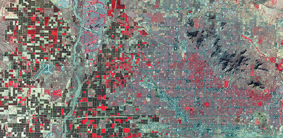
Landgrebe had long envisioned dividing the spectrum into narrower bands than the Landsat channels in order to map spectral signatures in greater detail. He was envisioning hyperspectral imaging. Melba Crawford, professor of agronomy at Purdue, explains the distinction: hyperspectral bands are contiguous, with no gaps between them, making it possible to resolve more details of molecular absorption and scattering signatures than multispectral scanners.

Melba Crawford, professor of agronomy at Purdue University
Interest in hyperspectral imaging has grown since the late 1980s, when the Jet Propulsion Laboratory (JPL) became NASA's center for developing hyperspectral technology. JPL makes airborne instruments available for research in a wide range of fields, including agriculture. Its current Airborne Visible/Infrared Imaging Spectrometer (AVIRIS) has 224 contiguous spectral bands stretching from 380 to 2510 nanometers. NASA's Earth Observatory, launched in 2000, carried a hyperspectral imager called Hyperion that had similar resolution. Europe, Japan, and China have all orbited hyperspectral imagers, and NASA is talking about launching one in the 2020s.
Hyperspectral imaging has become an important tool for improving agricultural crops to increase food security. At LARS, which since 1969 has been the Laboratory for Applications of Remote Sensing, Crawford's group uses hyperspectral imaging to analyze traits of crops planted in test fields. Big plant breeders develop many new strains of crops in their laboratories, then plant samples in small plots and quantitatively compare their traits by measuring performance such as growth rates and drought tolerance. Hyperspectral cameras that image plots as the plants grow gather extensive data that can be analyzed in detail to pick the most promising strains.
The next big thing is drone-borne hyperspectral imaging. Crawford cites "enormous progress" over the last five to ten years in gathering hyperspectral data from unmanned aerial vehicles (UAVs). In fact, as I finished this article, an email arrived inviting me to a webinar on "Lightweight hyperspectral imaging UAVs...for agricultural research and environmental monitoring" by a major maker of hyperspectral equipment.
Photonics is part of the technological toolkit making the world's food supply more secure and sustainable.
Jeff Hecht is an SPIE Member and freelancer who writes about science and technology.